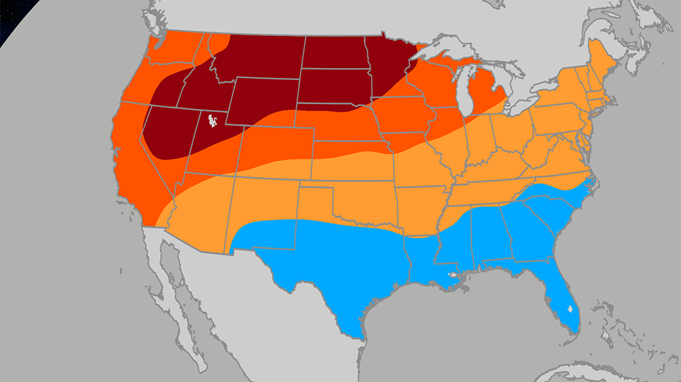
The latest June outlook points to a split across the country, with the Northeast trending cooler than the Northwest as summer gets underway. The Weather Company and Atmospheric G2 say the Northwest is likely to stay drier than normal, while the Great Lakes and much of the Upper Midwest may run warmer than average.
A cooler Northeast, but not a wet one
The Northeast stands out in the new outlook because it is expected to be drier than normal even as temperatures stay less intense than in the Northwest. That combination can still make the region feel more comfortable than areas where heat and humidity build faster.
The change matters because the latest forecast is not simply about rain or lack of rain. It also shows how regional temperature patterns are shifting as June opens, with some areas moving toward stronger summer heat while others avoid the sharpest warmth.
Northwest heat builds early
The Northwest is forecast to stay on the dry side, and that often supports faster warming. The outlook suggests a warmer start to summer across the Upper Midwest to the Intermountain West, where conditions may feel closer to July or August than to early June.
That warmer signal is one of the major shifts in the updated forecast. Compared with the earlier outlook, the Great Lakes region is now expected to turn warmer to much warmer than average instead of hanging onto springlike temperatures.
South sees a different setup
The South is expected to be much cooler and wetter than in the previous outlook, especially in cities such as Miami, New Orleans and Dallas. More frequent rain can limit daytime heating and keep temperatures from climbing as quickly.
This wetter South fits with a broader pattern in the forecast that favors more moisture across parts of the country. It also shows how quickly the outlook changed from the earlier May 14 update.
What changed in the revised outlook
The newest forecast is noticeably different from the prior one in several key regions. The Northeast is now warmer than before, though it remains drier than average, while the Southwest still points to a wetter-than-normal monsoon even if the rainfall signal is not as strong as earlier expected.
That shift leaves the map with a more varied early-summer picture. Some regions are set up for heat and dryness, while others are more likely to see clouds and rain keep temperatures in check.
El Niño may already be shaping the pattern
A strengthening El Niño is expected to make the subtropical jet more active, according to the outlook. That stronger jet can steer more moisture into the Southern U.S., which helps explain the wetter signal there.
The same setup could also improve the monsoon across the Desert Southwest, offering some help to drought-stricken parts of Arizona, New Mexico, Utah and Colorado. At the same time, June periods that arrive before a strong El Niño often lean warmer and drier in the Northwest, which matches the latest forecast trend.