

Minnesota Weather: Overnight Freezing Rain Expected to Create Icy Conditions Thursday Morning
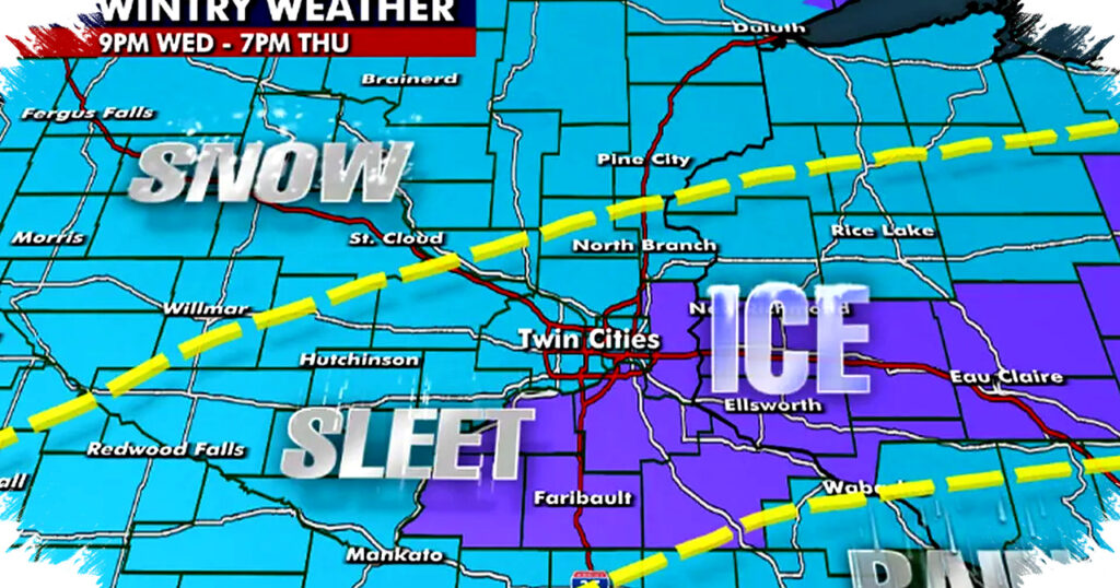
Minnesota is bracing for a messy overnight weather system that could make Thursday morning travel dangerous, especially in the Twin Cities metro and parts of northern Minnesota. Forecasters say a mix of rain, sleet, snow, and freezing rain will move in late Wednesday and continue through early Thursday, raising the risk of icy roads, slushy streets, and slower commutes.
The National Weather Service has already responded with winter weather alerts for much of the state. A winter weather advisory covers a large portion of Minnesota from midnight through Thursday, while a winter storm warning remains in effect for the Twin Cities metro and the Arrowhead region through noon Thursday because of heavier mixed precipitation and hazardous travel.
What to Expect Wednesday Evening
Wednesday starts quiet across most of Minnesota, but cloud cover will increase as the day goes on. Temperatures are expected to stay in the mid-40s, which is slightly below average, and winds will remain light from the northeast.
Most areas should stay dry for much of the day, although a few isolated showers could reach western Minnesota by late afternoon. The main round of moisture is expected to arrive after sunset, when road conditions begin to worsen.
Twin Cities Timeline for Snow, Sleet, and Freezing Rain
The most concerning period for the metro is overnight Wednesday into Thursday morning. Forecasters expect the storm to transition through several precipitation types as temperatures fall, which can create fast-changing road conditions.
- 6 p.m. to midnight: Light rain moves into the metro with a mix of snow and sleet, while temperatures hold in the upper 30s.
- Midnight to 6 a.m. Thursday: Sleet and freezing rain become more likely as temperatures drop into the low 30s with gusty easterly winds.
- 6 a.m. to Thursday afternoon: Conditions should slowly improve after sunrise and later in the morning, with precipitation changing over to mainly rain and temperatures staying in the mid-30s.
That overnight shift is what makes the commute risky, since even a thin layer of freezing rain can coat roads, bridges, sidewalks, and untreated surfaces with hard-to-see ice.
Why the Travel Risk Is High
Freezing rain is especially dangerous because it can fall as liquid and freeze on contact with cold pavement or objects. That can create black ice, reduce tire traction, and make walking conditions hazardous even when snowfall totals stay modest.
Gusty east winds may also add to the problem by pushing moisture across roadways and reducing visibility at times. Commuters heading out early Thursday should expect delays, especially in areas where treatment crews have less time to respond before temperatures bottom out overnight.
Areas Under Alert
The winter weather advisory and winter storm warning highlight the parts of Minnesota most likely to see impactful wintry weather. The warning zone includes the Twin Cities metro and the Arrowhead, where the combination of sleet and freezing rain could create the most difficult travel conditions through Thursday morning.
Residents in the advisory area should still prepare for slick roads, even if overall snowfall remains limited. Small changes in temperature during the night can shift precipitation from rain to ice very quickly.
What Drivers and Residents Should Do
Meteorologists are urging people to plan ahead before the overnight system arrives. A few simple steps can reduce risk during the highest-impact hours:
- Check road conditions before leaving home on Thursday morning.
- Allow extra travel time for a slower commute.
- Use caution on bridges, ramps, and untreated roads, where ice forms first.
- Keep an ice scraper, windshield washer fluid, and a winter emergency kit in the vehicle.
- Watch for school, transit, or work schedule changes if conditions worsen overnight.
Weather Outlook After Thursday
Another weather system is expected to follow quickly behind Thursday’s wintry mix, bringing more chances for rain and possibly snow from Friday into Saturday. That means slick conditions could return before roads fully recover from the first round.
Sunday is expected to turn colder but quieter, with sunshine returning across much of the state. Temperatures should remain slightly below average into early next week, keeping the region in a colder-than-normal pattern as the next weather systems are tracked.
Read more at: www.fox9.com