A rare spring Polar Vortex core is extending winter-like weather risks into April, with the latest model guidance pointing to renewed cold spells, late snowfall, and sharp temperature swings across parts of North America and Europe. The upper-level Polar Vortex is in its final seasonal collapse, but a lower-atmosphere remnant is still active and can continue to steer cold air into the mid-latitudes.
Meteorologists note that this is a normal stage of the seasonal transition, but the timing matters. As the stratospheric circulation weakens during the so-called Final Warming, the remaining core in the lower atmosphere can still shape weather patterns for days or even weeks.
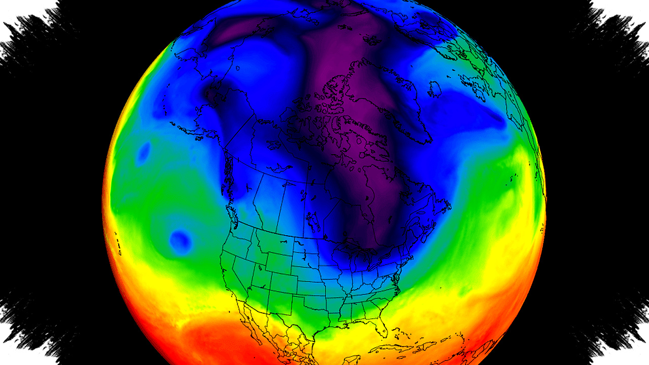
What the Polar Vortex means in spring


The Polar Vortex is a large-scale circulation that surrounds the polar regions and helps keep the coldest air trapped near the Arctic in winter. It has two main parts: a stratospheric component higher up and a tropospheric component closer to the surface, and the lower part can stay active after the upper part fades.
When spring warming reaches the stratosphere, that upper circulation loses strength and eventually dissolves. Once that happens, the atmospheric “wall” weakens, and fragments of cold air can drift farther south than usual.
Why the current setup matters
Current analysis shows a residual Polar Vortex core centered over North America and eastern Canada. That position favors northwesterly flow into the United States, which can deliver colder air, while Europe is more likely to see milder westerly or southerly air moving in from the Atlantic.
In simple terms, the pressure pattern can support a colder northern tier in the United States and a warmer start in parts of Europe. The setup also raises the chance of unsettled weather where the cold air meets moist systems moving through the middle latitudes.
Early-April risks: snow, ice, and below-normal temperatures
The forecast for the first part of April shows a low-pressure area tied to the residual core over eastern Canada and the North Atlantic. That pattern can pull in colder air across the northern and eastern United States, with some areas seeing temperatures about 10-20°F below normal.
The same pattern can also support late-season snow, especially across the northern Plains, the Upper Midwest, the Great Lakes region, and into eastern Canada. Parts of the Northeast may also see wintry bursts, although snow accumulation is expected to stay limited in many areas because of the seasonal warmth and changing ground conditions.
For the U.S., the most disruptive impacts are expected in a corridor from the Dakotas into Minnesota and Wisconsin, where heavy wet snow and icing could affect travel and power lines. NOAA-based winter storm severity guidance for the early part of the month also highlights significant impacts in that region.
Areas under the strongest early impacts
- Northern Plains and Upper Midwest: heavy snow and ice risk.
- Wisconsin and Upper Michigan: hazardous icing and difficult travel.
- Colorado Rockies: stronger winter storm impacts in mountain zones.
- Maine, New Hampshire, Vermont, and upstate New York: brief “winter in spring” conditions.
- Eastern Canada: lingering cold and scattered snow bands.
Europe has a different story in the first week of April, with the forecast leaning warmer and more seasonable overall. Central areas may stay relatively dry, while precipitation risks shift toward the southeast and northwest.
Mid-month: the cold core lingers
By the middle of the month, model guidance keeps the low-pressure Polar Vortex core over northern Canada while a high-pressure zone builds farther north. This keeps northwesterly flow in place over the northern United States and can continue to feed colder air into the Midwest, Great Lakes, and Northeast.
That pattern also supports a brief warmup farther south and east, because low-pressure systems can draw warmer air ahead of them. Over Europe, the same broad setup may produce another round of below-normal temperatures in parts of the continent, along with a split in precipitation trends.
Forecasters say more snow bands can still develop in the second week of the month across the Midwest and Upper Midwest. In Europe, the colder signal is not winter-like, but some areas may run about 5-10°C below normal.
Late April may shift toward blocking
Later in the month, the atmosphere may begin to reorganize into a more blocked pattern. Long-range guidance suggests the possibility of an Omega Blocking setup, where high pressure dominates the middle of the pattern and low pressure sits on both sides.
That type of blocking can slow weather systems and create a sharper divide between warmer and cooler regions. In this case, the central United States would be more likely to stay warmer under high pressure, while cooler air could return to the Northeast, the Midwest, the Pacific Northwest, and southern Canada.
What an Omega block can do
- Trap warm air under the central ridge.
- Funnel cooler air into the flanking lows.
- Increase weather contrast across short distances.
- Slow the movement of storm systems.
- Extend unsettled spring conditions in some regions.
Europe may also see more variation late in the month, with cooler tendencies over much of the mainland and warmer anomalies farther north. The broad signal remains consistent with a late-season atmospheric reset, not a full return to winter.
Why the forecast still carries uncertainty
At longer ranges, model patterns are more useful for identifying broad trends than exact local outcomes. Small changes in the position of the Polar Vortex core can shift the coldest air, snowfall bands, and storm tracks by hundreds of miles.
Even so, the latest guidance supports a clear message for early spring: winter risks are not fully over yet. A weakening stratospheric Polar Vortex can still leave behind a lower-level cold core that influences North American and European weather well into April.
Read more at: www.severe-weather.eu