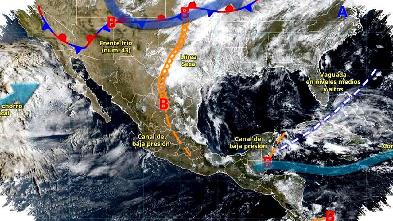
The Mexico City metropolitan area and the Valley of Mexico will face a sharp contrast in weather on Monday, April 6, as a polar air mass linked to Cold Front 43 keeps early-morning temperatures low before daytime heat develops. The National Meteorological Service (SMN) said the same system will also bring afternoon showers to the region, making the start of the week cold, warm, and rainy in different parts of the day.
According to the SMN, the pattern comes from a Gulf of Mexico branch moving gradually while interacting with a low-pressure channel over southern Mexico. That combination will keep unstable weather in place across several central states, with the capital and the State of Mexico among the areas expected to see both frost risk at dawn and scattered rainfall later.
Cold start for high-altitude areas


The SMN forecast minimum temperatures between -5 and 0 degrees Celsius in mountainous areas of Mexico City, Hidalgo, the State of Mexico, Tlaxcala, Puebla, and Veracruz during the early hours of Monday. Those values raise the risk of frost in elevated zones, especially where winds and clear skies can intensify the cold before sunrise.
In the capital region, the warning matters for residents in the higher parts of the city and nearby mountain communities. The weather office said temperatures can shift quickly after dawn, so the cold period will be short but intense enough to affect outdoor activity and early travel.
Heat returns during the day
Once the sun rises, the same region will warm up fast. The SMN projected highs of up to 30 degrees Celsius for Mexico City and the State of Mexico, creating a strong contrast with the freezing start of the day.
That swing is typical of early April in central Mexico, when dry morning air and strong daytime heating can push temperatures upward within a few hours. Drivers, commuters, and people working outdoors may need to prepare for both a cold morning and a hot afternoon on the same day.
Showers expected in the afternoon
The SMN also forecast intervals of showers, ranging from 5 to 25 millimeters, for Hidalgo, the State of Mexico, Mexico City, Tlaxcala, and Morelos on Monday afternoon. While the rainfall is not expected to be extreme in the capital area, it can still affect traffic, visibility, and local drainage in some neighborhoods.
The agency noted that this weather pattern is part of a broader atmospheric setup that will keep moisture and instability over central and southern Mexico. That increases the chance of cloudy skies and brief rain bursts after a dry and warm stretch during the middle of the day.
What to expect on Tuesday
Conditions on Tuesday, April 7, should remain similar. The SMN said minimum temperatures between -5 and 0 degrees Celsius with frost are expected in the mountain areas of Baja California, Sonora, the State of Mexico, and Puebla.
For the capital region, early-morning temperatures of 0 to 5 degrees Celsius are forecast in the mountainous areas of Mexico City, Hidalgo, Tlaxcala, and Veracruz. Rain chances will also expand, with showers expected in Chihuahua, Coahuila, Nuevo León, Tamaulipas, San Luis Potosí, Michoacán, Guanajuato, Querétaro, Hidalgo, State of Mexico, Mexico City, Tlaxcala, and Morelos.
- Early morning: very cold conditions in high-altitude areas.
- Midday: warm to hot weather in Mexico City and the State of Mexico.
- Afternoon: scattered showers with possible traffic impacts.
- Next day: similar temperatures and broader rainfall chances.
Broader weather risks across Mexico
The SMN said a trough in middle and upper levels of the atmosphere, together with the subtropical jet stream and atmospheric instability, will support strong to very strong rain in northeastern, eastern, and southeastern Mexico. The agency added that the Yucatán Peninsula could also see this pattern, with isolated heavy rain in Hidalgo, Puebla, Veracruz, Oaxaca, and Chiapas.
For central Mexico, including the Valley of Mexico, that means the weather may stay changeable through the start of the week. Residents are being advised to follow official updates closely, since forecast conditions can shift as the cold front and moisture patterns evolve.
Read more at: es-us.noticias.yahoo.com