Strava is giving hiking a more practical edge at a time when outdoor activity is gaining momentum across its platform. The latest update focuses on two things hikers value most: staying on course in difficult terrain and sharing the journey in a way that is easier to understand at a glance.
The move comes as hiking participation continues to rise within Strava’s ecosystem. The fitness platform now has more than 195 million users in over 185 countries, while hiking clubs reportedly grew 5.8 times during 2025 according to the company’s Year In Sport report.
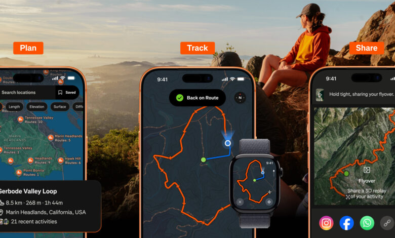
Planning Routes With More Detail
Route preparation is becoming a bigger part of the hiking experience, especially for users who want to avoid wasted time and unclear paths. Strava is responding with updated mapping tools that provide more context before a hike even begins.
The most visible change is a richer map view that shows trail surface conditions more clearly, along with campsites, picnic spots, and trailheads. For subscribers, Strava also adds Route Discovery powered by global heatmap data, making it easier to spot popular hiking paths in different areas.
The Route Builder gives users another layer of control by letting them shape a path around their own needs. Distance, elevation, and terrain details appear in real time, which helps set expectations before setting off.
There is also Route Saving, allowing users to store favorite routes from different parts of the app and reopen them later when needed.
Navigation Tools for Uncertain Terrain
Once hikers are on the trail, staying on the correct route becomes the priority. Strava’s new navigation features are aimed at reducing mistakes when signal fades or the landscape becomes harder to read.
Off Route Alerts notify users when they move away from the planned trail, giving them a chance to correct course quickly. Apple Watch users can also follow routes directly from the wrist instead of repeatedly checking a smartphone.
Strava has broadened device support as well, with route syncing now available for popular wearables including Garmin, Apple Watch, and Coros. For areas with weak or no connectivity, Offline Routes let users download a trail in advance and keep navigating without an internet connection.
The navigation package also includes Mobile Map Recording, which keeps a full-screen map visible during the activity, and Real-Time Elevation, which helps hikers monitor the climb and manage pace more effectively.
A Stronger Social Layer for Sharing the Hike
Strava is also leaning into the social side of outdoor activity, giving users more ways to present a hike to friends and club members. The new 3D Activity Map shows the full route with topography and elevation details in a more visual format.
The platform has also introduced Activity Replay, which automatically brings a favorite hike back into the home feed so the community can follow the trip from start to finish. For those who prefer quick sharing on social media, Stat Stickers turn distance, elevation, and duration into a visual summary.
Clubs remain an important part of that community experience. Within Clubs, users can share routes, join group challenges, and compete on leaderboards, keeping hiking connected to the platform’s social features.
For subscribers, Flyover stands out as one of the most polished additions. It creates a cinematic 3D animation based on real elevation data, giving shared hikes a more dynamic look.
Rollout Timeline
Most of Strava’s latest hiking features are already available to users. The refreshed map design, which is intended to look more modern and provide more useful detail, will roll out gradually between September and October this year.
With these changes, Strava is positioning itself as more than an activity tracker. The platform is now pushing hiking toward a fuller experience that combines planning, offline navigation, and easier sharing in one place.