Satellite images obtained by Reuters show a structure at the entrance of Scarborough Shoal in the South China Sea, adding a new layer to the long-running dispute over one of the region’s most contested maritime sites. Later imagery suggests the object was no longer visible, leaving questions about what it was and how long it remained there.
The Philippines has said it is investigating reports of the new structure, while China has not immediately responded to requests for comment. The images have renewed attention on Scarborough Shoal, where tensions have repeatedly flared between Chinese and Philippine forces and where analysts warn that friction could escalate further.
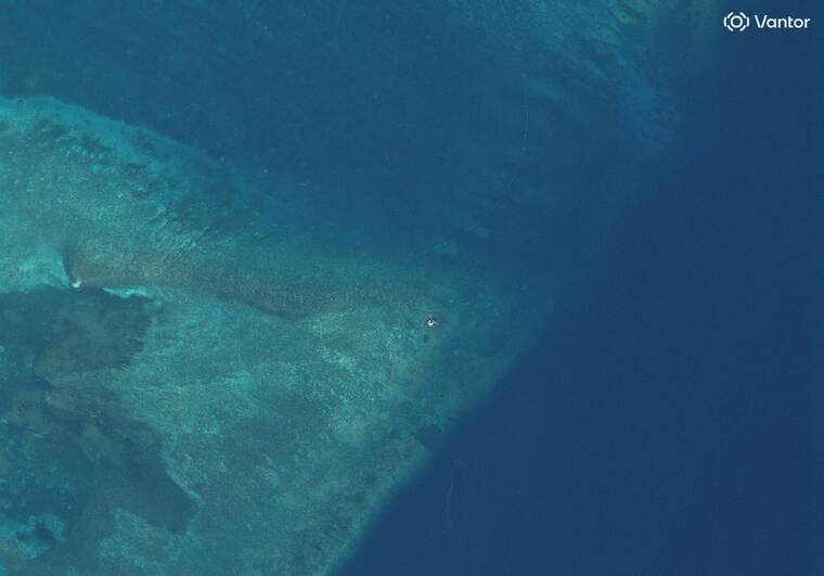
What the images showed


Photographs taken on May 27, May 29 and May 30 appear to show what a Vantor analyst described as a possible floating raft or buoy near the opening of the atoll. In the May 27 and May 29 images, a barrier also appeared to stretch across the opening.
SeaLight, a U.S.-based maritime monitoring group, said satellite imagery taken on May 28 showed a “small, reflective object clearly distinguishable on the reef flat near the lagoon entrance.” The group added that its review of additional satellite images suggested the object was a persistent feature rather than a brief optical effect.
That apparent structure could not be seen in a June 1 image taken by Vantor, which Reuters reported as the first evidence that the suspected object was no longer present.
Philippine response and regional concern
Defense Secretary Gilberto Teodoro said he had received raw information about the structure, according to comments made to reporters on the sidelines of the Shangri-La Dialogue in Singapore. The Philippine government’s review comes as Scarborough Shoal remains a sensitive flashpoint in the South China Sea.
The shoal, which China calls Huangyan Dao, sits near major shipping lanes and is valued for its fish stocks and its lagoon, which offers shelter to vessels during storms. Chinese coast guard vessels have frequently clashed with Philippine fishermen in the area in recent years.
Diplomats and analysts have long warned that disputes around the shoal could worsen into armed conflict if confrontations continue. The concern has intensified because the site remains central to broader rival claims in the South China Sea.
A dispute shaped by patrols, drills and legal battles
China’s military and coast guard conducted patrols in the area on Sunday, shortly after Philippine and U.S. forces held a five-day maritime exercise in the same waters. That was the third such drill this year, and it was intended to improve interoperability and maritime security.
The legal backdrop also remains unsettled. A landmark 2016 ruling by the Permanent Court of Arbitration backed Manila on several South China Sea issues, but it did not decide sovereignty over Scarborough Shoal. The court did say Beijing’s blockade there violated international law because the area was a traditional fishing ground used by several countries, including China, the Philippines and Vietnam.
Last year, China announced a national nature reserve at the shoal, a move that the Philippines quickly condemned as a “clear pretext for occupation.” The latest satellite images now add another unresolved detail to a dispute that continues to shape security dynamics across the South China Sea.
Read more at: www.staradvertiser.com