


Weather models are now pointing to a much stronger El Niño than many forecasters expected, raising the odds of a winter with heavier storms, higher temperatures, and wider global disruptions. The National Oceanic and Atmospheric Administration’s Climate Prediction Center said there is a 97% chance the event will be strong or very strong over the three months ending in December.
That matters because a very strong El Niño is often called a “super” El Niño, and officials say the warming pattern in the tropical Pacific can amplify heat waves on land and at sea. Those effects are arriving against a backdrop of already warming oceans and human-caused global warming, which can intensify the risks even further.
What Makes El Niño So Powerful
El Niño is a climate pattern that typically appears every two to seven years and lasts about nine to 12 months, according to NOAA. It begins when warmer water gathers in the central and eastern tropical Pacific, while the usual east-to-west trade winds weaken or even reverse.
That shift helps warm water move east through a downwelling oceanic Kelvin wave, said Jon Gottschalck, chief of the Climate Prediction Center’s operational prediction branch. As the temperature gap between the western and eastern Pacific shrinks, the winds weaken further, creating a feedback loop that pushes even more warm water eastward.
What The Current Forecast Suggests
The latest outlook from NOAA’s Climate Prediction Center says there is an 81% chance the event will be very strong. Authorities declared the arrival of El Niño last month, but the climate pattern takes time to build to full strength.
Below is a quick look at how the latest forecast breaks down.
| Forecast Measure | Latest Outlook | Meaning |
|---|---|---|
| Chance of strong or very strong El Niño | 97% | Expected by the three months ending in December |
| Chance of very strong El Niño | 81% | “Very strong” events are often called “super” El Niños |
How The Weather Impacts Could Spread
El Niño typically changes weather patterns around the world, with the impact depending on the season and location. Ariel Cohen, a meteorologist with the National Weather Service in Oxnard, said warmer water off Mexico, Central America, and northern South America often helps steer more stormy weather into the southern United States during winter.
That usually includes Southern California, Texas, and Florida, while places farther north such as the Pacific Northwest often see drier-than-normal conditions. Cohen said El Niño can also bring very dry conditions to Australia and northern South America, while eastern Africa may experience wetter weather.
“There’s really a wide array of impacts that can come that vary significantly from place to place across the globe,” Cohen said.
Climate scientist Zachary Labe of the nonprofit Climate Central said the warming pattern can temporarily boost global temperatures. He added, “This would indicate a very high likelihood that we will be breaking new global temperature records in just a few months.”
Why Southern California Is Watching Closely
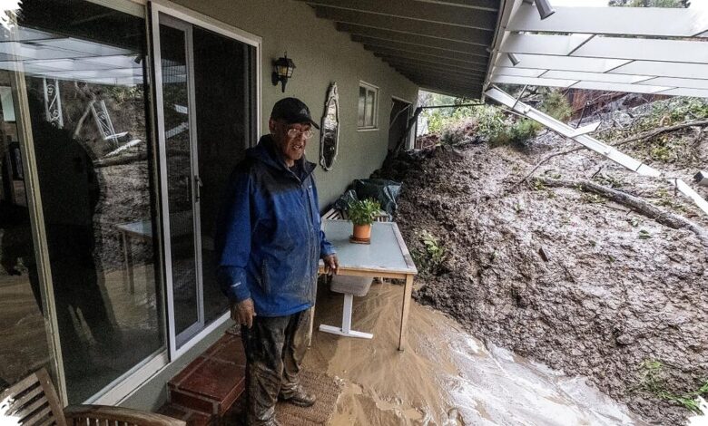
For Southern California, the main concern is a higher chance of above-average rainfall and the flooding and landslides that can come with it. During three of the four very strong El Niños in the global record, downtown Los Angeles received significantly more rain than average, and in 1982-83 and 1997-98 it got more than double its usual yearly rainfall.
The relationship is not guaranteed, though. During the last very strong El Niño in 2015-16, downtown Los Angeles received only half of its typical annual rainfall, showing that every event plays out differently.
The most recent El Niño, in 2023-24, was classified as strong. For the water year ending Sept. 30, 2024, downtown Los Angeles recorded 22.15 inches of rain, or 155% of its average annual rainfall of 14.25 inches.
That season brought hundreds of landslides across Los Angeles and the second-rainiest three-day period for downtown Los Angeles since recordkeeping began in 1877, according to www.latimes.com. Coastal Southern California also saw well-above-average rainfall, while coastal Northern California was slightly above normal and interior areas such as the Sierra Nevada and southeastern California deserts came in below normal.
Marine Heat, High Tides, And Coastal Risk
Officials are also warning about added pressure on the ocean itself. This year’s El Niño is expected to prolong an existing marine heat wave off the Southern California coast, while the very strong 2015-16 event brought record coastal erosion along many California beaches, according to the state Coastal Commission.
High-tide flooding is another possibility when El Niño is active, adding another layer of concern for coastal communities already dealing with warmer waters. Scientists also say warming oceans can provide extra energy to storms, increase evaporation, and contribute to sea level rise.
A World Already Running Hot
On July 1, officials confirmed that the global sea surface temperature in June hit a record for that time of year. The World Meteorological Organization said El Niño can increase global temperatures and intensify heat extremes over nearby land areas.
Carlo Buontempo, director of the Copernicus Climate Change Service, said, “Current conditions could indicate the beginning of a new phase, leading, once more, to uncharted territory.” He added that with ocean temperatures at these levels and El Niño approaching, more temperature records are likely to fall in the coming months.
The Copernicus Climate Change Service and Copernicus Marine Service say warming ocean waters can also stress marine ecosystems and help drive extreme precipitation and flooding. That combination leaves the coming months looking unusually risky, especially for places where El Niño and already elevated sea temperatures overlap.