Google Maps can do more than show where a place is today. In certain locations, it also lets users look back at how streets and homes appeared in the past through archived Street View imagery.
This feature is useful for anyone who wants to compare how an area has changed over time. It can show the growth of neighborhoods, the appearance of new buildings, and shifts in road layouts.
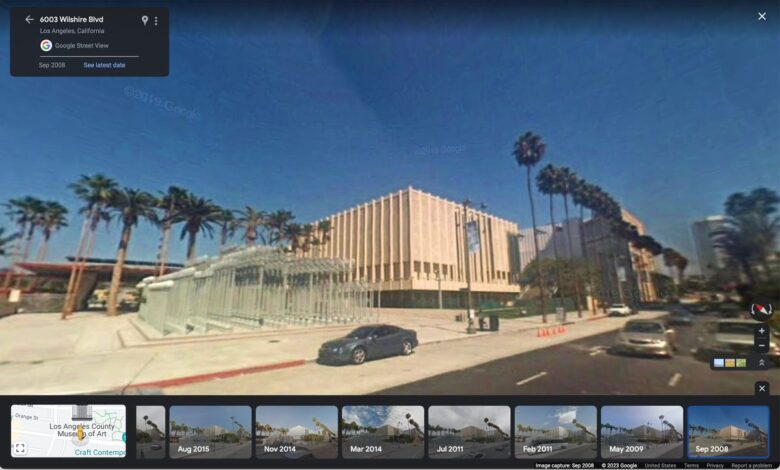
Street View history on desktop
On a computer or laptop, users can open Google Maps in a browser and search for the location they want to inspect. After that, they need to drag the yellow Pegman icon onto a blue-highlighted road or area to enter Street View.
Once inside Street View, a “See more dates” or “Lihat tanggal lainnya” option may appear in the upper-left corner. Selecting it displays a timeline of images from different years, allowing users to choose the period they want to view.
How it works on smartphones
The same kind of access is also available in the Google Maps app on Android and iPhone. Users can press and hold a location on the map until a pin appears, then tap the Street View thumbnail shown at the bottom of the screen.
After Street View opens, the date information at the top of the screen can be tapped to reveal other available dates. This makes it possible to check the same place from different periods directly on a phone.
Not every location has the same depth of archive, however. Google’s Street View coverage depends on how often its vehicles have photographed a particular area, so some places offer more historical images than others.
Google Earth adds satellite history
Google Earth also offers a way to look into the past through Historical Imagery. This feature is separate from Street View and focuses on satellite images that show how a place has changed from above.
Users can open Google Earth and select Historical Imagery from the toolbar, where it is marked by a globe icon with a circular arrow. The tool is often used to track city growth, coastline changes, forest conditions, and long-term urban transformation.
With Street View archives and Historical Imagery, Google’s mapping services become more than navigation tools. They also provide a visual record that helps users trace how a location has evolved year by year.