A powerful winter storm classified as Winter Storm Iona is currently impacting the Upper Midwest and Great Lakes region with blizzard conditions and record-setting snowfall. The storm is moving in tandem with high winds, causing hazardous travel and severe disruptions across multiple states.
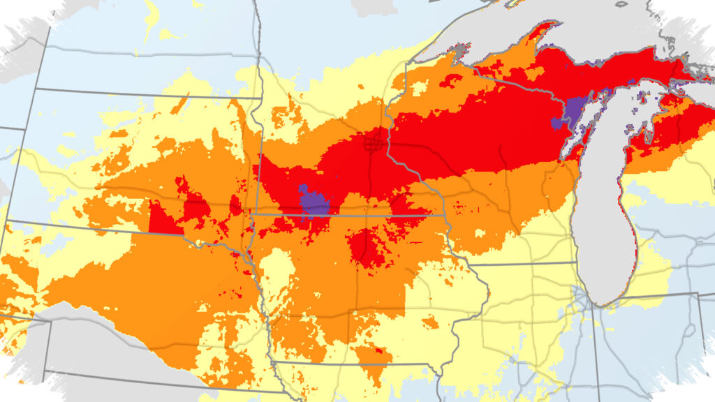
Snowfall rates of 1 to 3 inches per hour have been reported in parts of Wisconsin and Michigan. Accumulations exceeding 20 inches have already been recorded from southern Minnesota through central Wisconsin, with Marinette, Wisconsin notably receiving 28 inches. This intense snowfall follows a period of unseasonably warm temperatures and severe weather outbreaks in the central and eastern United States.
Areas Most Affected by Snow
The heaviest snow is concentrated in the following areas:
- Southern Minnesota
- Central and northern Wisconsin
- Far northern Lower Michigan
- Upper Michigan
Regions such as Green Bay, Marquette, and Mackinac Island can expect snowfall totals ranging from 1 to 3 feet. Some localized spots in northern Michigan could receive up to 4 feet of snow. Marquette has already surpassed 214 inches of snow since early October, ranking it among the top five snowiest periods on record for that timeframe.
Accompanying strong winds exacerbate the situation, creating whiteout conditions and rendering travel extremely dangerous to impossible. Authorities advise residents and travelers in the affected zones to delay or cancel travel plans until conditions improve.
Winter Weather Alerts and Risks
Various winter weather alerts are in effect, covering:
- Blizzard warnings in areas experiencing heavy snowfall.
- Freezing rain and sleet expected in parts of extreme northern Iowa, southern Minnesota, southern Wisconsin, and Lower Michigan, increasing the risk of slippery roads.
- High wind warnings that could contribute to tree damage, power outages, and the spread of fires in certain regions.
Power outages are particularly concerning near the Great Lakes and along the immediate East Coast, where sustained gusts are predicted into Monday.
Storm Progression and Impact Beyond the Midwest
By Monday, the storm’s low pressure system is forecast to push a cold front rapidly eastward. Snow showers may briefly develop in areas of the Ohio Valley and Appalachians that were recently affected by storms. The East Coast will primarily experience rain, coupled with a threat of severe thunderstorms producing damaging winds from the Northeast down to the Carolinas.
Strong winds are expected to persist across much of the Midwest and East, further complicating recovery and cleanup efforts.
Temperature Drops and Duration of Cold Weather
Following the blizzard, frigid air from Canada will plunge southward through the Plains, reaching the northern Gulf Coast by Monday and sweeping through the East by Tuesday, including Florida. Temperatures will remain well below normal for several days:
- Highs in the teens to 30s common across the Midwest.
- Subzero temperatures possible in North Dakota, Minnesota, Wisconsin, and Michigan’s Upper Peninsula.
- Freezing lows forecast in the Deep South, affecting areas as far south as northern Florida.
Several daily record lows and cold highs may be challenged, especially in the Deep South, where frost and freezing conditions could occur in cities such as Mobile, Alabama, and New Orleans.
Outlook for the Week Ahead
Warmer air is anticipated to return to the Plains by midweek, gradually spreading eastward later in the week. However, some forecasts suggest that cold air could briefly return to the Midwest and Northeast around the following weekend, continuing the pattern of strong weather fluctuations characteristic of this time of year.
Residents in affected and neighboring areas should stay informed on weather updates and maintain preparedness for rapidly changing conditions.
Read more at: weather.com