The Tornado Watch has ended for the Kansas City area, and storm coverage is expected to move out of the eastern counties around midnight. A much quieter stretch follows overnight, but another round of severe storms is expected to develop Tuesday afternoon and continue into the night.
The immediate tornado threat is now very low, according to the latest forecast, though strong winds and hail remain possible until the storms fully clear. Flood Warnings also remain active for several counties, with Douglas and Franklin under an alert until 12:30 AM and Cass, Johnson, and Miami counties under a Flood Warning until 4 AM Tuesday.
Storm risk eases overnight
After midnight, forecasters expect dry conditions to take over for the rest of the night. Skies should stay partly cloudy and breezy, while temperatures fall only slightly, with lows around 68 degrees by Tuesday morning.
That low would tie the record warmest low temperature from 2006, adding to the unusual start to the day. The warm overnight setup is one reason the atmosphere may remain favorable for storm development later on.
Tuesday brings the next severe weather window
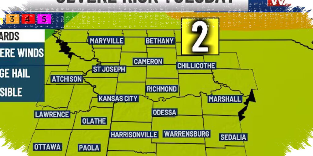
Conditions are expected to warm quickly Tuesday, with increasing clouds during the afternoon and a renewed chance for severe weather by late day. The Storm Prediction Center has placed the region under a 2 out of 5 severe weather risk, which signals a conditional threat that depends on storms developing to the west and moving into the area.
Forecast timing points to the highest risk between 6 PM and midnight, when storms may fire in Kansas and track toward the Kansas City metro. If storms form, the main hazards will be hail and damaging wind, while a few brief tornadoes cannot be ruled out.
What residents should prepare for Tuesday
- A 60% chance of rain and severe storms.
- Warm highs in the upper 80s.
- Southwest wind gusts up to 30 mph.
- The strongest storm potential late afternoon through nighttime.
- Hail and wind as the primary hazards, with a low but nonzero tornado risk.
Meteorologists say the severe threat is not guaranteed, but the setup is close enough to warrant close monitoring through the evening. That is especially important for commuters, outdoor workers, and anyone with evening travel plans.
Another round could follow on Wednesday
A second severe storm threat may arrive Wednesday, depending on how Tuesday’s storms evolve and move out. Forecast guidance points to another level 2 out of 5 risk, with the best chance for strong to severe storms late in the day and into the night.
Wednesday could also start with scattered rain or storms in the morning, which would affect later storm chances. Temperatures are expected to be slightly cooler in the upper 70s, but breezy conditions should continue through much of the day.
Later-week pattern stays active
Thursday is expected to bring a break from the stormy pattern, with sunny skies, dry conditions, and temperatures in the mid-80s. That calm may not last long, because storm chances return again Friday with another possible line of storms late in the day and overnight.
Friday’s setup looks similar to earlier days, with a 2 out of 5 severe risk and threats focused mainly on wind and hail. Before storms arrive, the region could see another unusually warm afternoon in the low 80s, along with south winds gusting up to 35 mph.
Expected weather impacts by day
| Day | Main Forecast | Severe Risk | Key Hazards |
|---|---|---|---|
| Overnight | Dry after midnight | Low | Residual wind, some flooding concerns |
| Tuesday | Warm, breezy, storms late | 2/5 | Hail, wind, brief tornadoes possible |
| Wednesday | Cooler, storm chances return | 2/5 | Hail, wind |
| Thursday | Sunny and dry | None mentioned | None |
| Friday | Warm with late storms | 2/5 | Hail, wind |
| Weekend | Cooler with lingering rain possible Saturday | Lower | Rain early Saturday |
The weekend forecast brings a notable cool-down after the active stretch, with a chance for lingering rain Saturday morning before dry weather returns. Highs look much cooler, with upper 50s expected Saturday and mid-60s on Sunday, while northwest winds keep the air feeling brisk across the region.
Read more at: www.kctv5.com