
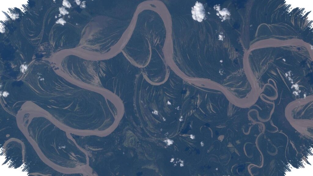
NASA astronaut Jessica Meir captured a dramatic view of a river winding through the Amazon rainforest from the International Space Station. The image shows the Ucayali River in central Peru, a major waterway that forms part of the broader Amazon system and stands out clearly as it cuts across the landscape.
The photo offers more than a beautiful look at Earth from orbit. It also highlights a region known for rich biodiversity, deep Indigenous heritage, and continuing environmental pressure.
What the image shows
The Ucayali River appears as a light brown ribbon against darker land and water below, with small clouds floating above. From space, its curves and scale make the river easy to identify, even as it threads through dense rainforest.
Meir took the image while aboard the International Space Station after arriving on Crew-12, a SpaceX mission that launched in February. The four Crew-12 astronauts were welcomed by Expedition 74 and are expected to spend about eight months conducting research on the station.
Why the Ucayali matters
The Ucayali is a lower extension of the Apurímac River and is considered one of the main sources of the Amazon River. At more than 1,600 miles, or 2,700 kilometers, long, it supports a wide range of life and communities across central Peru.
The river basin is home to many Indigenous people, along with wildlife that includes pink dolphins, manatees, taricaya turtles, jaguars, giant river otters, catfish, monkeys, reptiles, and birds. That combination of human and natural diversity makes the region one of the Amazon’s most important and closely watched areas.
Pressure on a fragile region
Despite its ecological value, the Ucayali region faces continuing harm from illegal logging and commercial fishing. The area has also long been vulnerable to extraction, with a history shaped in part by the rubber boom of the late 19th and early 20th centuries.
The image therefore carries two messages at once. It shows the Amazon’s scale and beauty, while also pointing to the ongoing need to monitor threats to forests, rivers, and the people who depend on them.
Why views from space matter
Photos like this help reveal patterns that are difficult to see from the ground. Satellite imagery and orbital photography can show changes linked to deforestation and climate change, making them valuable tools for scientists and observers alike.
From orbit, the Ucayali looks like a moving line drawn across the rainforest. On the ground, it remains a vital river system whose condition says much about the health of the wider Amazon basin.